
Google Maps now has detailed map tiles for the major cities in China.
If you want to have a good look around the stadiums built for the Beijing Olympics 2008 you should visit EarthSwoop's Beijing Olympics collection of 3d buildings. EarthSwoop use the Google Earth Browser plug-in to show 3d buildings built for Google Earth.
I also received an e-mail today from noicon.biz to say that Google Maps in Japan has been updated to show the names of some houses and commercial locations. You can see this change in the screen-shot below where some buildings seem to have been tagged with little red dots. 
Showing posts with label maps. Show all posts
Showing posts with label maps. Show all posts
Tuesday, July 22, 2008
 Beijng Olympics - Google Mapified

Saturday, July 12, 2008
Google Maps For YouTube
You have been able to search for YouTube videos whilst in Google Maps for a while now but until now YouTube has not had its own geographical search feature. This means that in the past when you searched for say Paris in YouTube you would be shown hundreds of videos by someone called Paris Hilton (who my girlfriend informs me is not actually a hotel in the French capital).
Now when you search for Paris in YouTube a small map appears next to the videos of a scantily clad woman.
When you click on the map you are then taken to a larger map with a red polyline circle. You can move the circle around or you can zoom in to focus on a smaller area and YouTube will look for videos geo-tagged in that area. 
This is an excellent addition to YouTube. It has been one of my biggest bugbears with the site that a search for a geographical location often returned videos that had no relation to the actual place.
Thursday, July 10, 2008
Google Sightseeing Goes Multilingual
Google Sightseeing have released three new translations of Google Sightseeing: Dutch, German and Spanish. These three new blogs join Google Sightseeing's successful existing translations of French and Italian, so you can now sightsee around Google Maps in six different languages.
If you have never visited Google Sightseeing you should do now! Google Sightseeing is a directory of amazing satellite views culled from Google Maps and Google Earth. Everyday Google Sightseeing posts new weird and wonderful sights as suggested by their readers.
Google Sightseeing even have their own Google Map of submitted sights.
Tuesday, July 08, 2008
Walking Directions in Testing - Google Maps
Google Maps tests a new feature: walking directions. You can already get driving directions and, for a small number of locations, Google Maps has transit directions, but these directions are not always useful if you don't use a car or a bus.
Google suggests to "use caution when walking in unfamiliar areas", since the "walking directions are in beta". Chris, who sent this tip, spotted the feature for New York, but it's likely that Google randomly selected a small number of users to try the new feature and send feedback.
Measure it in Live Maps
This post by Greg Sterling this AM is a good reminder to tell you about one of my favorite features on Live Maps – Distance and Area calculations. If you ever wanted to know how far it is between 2 cities or what the area of the surface of a given lake is, Live Maps drawing tools make it really easy.
Even without drawing you can calculate directions to get the approximate drive time and distance between any 2 points by right clicking and choosing ‘Drive From…’ and ‘Drive to…’. Live maps has intercity vector map data for just about everywhere on Earth, including places it doesn’t have detailed city streets for.
But you can tailor the trail by using the Collections –> Open Your Collections menu to draw your own lines or shapes. Whether it is a simple 2 point line or a complex closed polygon, Live Maps will show you the distance and area/perimeter respectively. Here is Greg’s ‘Crow Flies’ distance from Haifa to Sfat.
And here is a Polygon drawn around the nearby Sea of Galilee showing that it is 63.33 Square Miles. If you sign in with your Live ID you can save your drawings in the cloud making them easy to share with others without the need for really long URL’s.
Friday, July 04, 2008
Live Maps - overseas improvements
 A handful of new features have just been rolled out for the international versions of Live Maps.
Live Search Maps China has just had a handful of additions and improvements, including:
- Real-time Traffic in Beijing
- Send-to-Mobile for free for local search and transit routing result
- Transit data refresh for existing 11 cities including 3 new subway in Beijing (No.10, Airport and Olympic).
- Expanded coverage from 11 to 31 cities.
- Geocoding and Local Search
- Data refresh for existing 114 cities including Olympic Venues.
- Support city and county name geocoding for areas outside of 114-city coverage.
- Olympic query relevance improvement
- Local search category refinement
- Map refresh for 10 existing major cities including Beijing, Shanghai, Guangzhou etc.
- Expanded tile coverage for 30 more cities, totally 289 cities now.
Tuesday, July 01, 2008
Amazing Google Maps Mania Timeline
Google Maps Mania Time-Line
The Google LatLong team have celebrated the third birthday of the Google Maps API (released on June 29th, 2005) with an amazing time-line of Google Maps Mania posts as well as posts from the former Google Maps API Blog. A quick scan of the time-line suggests that all of the over 1500 posts that have appeared on Google Maps Mania are included on the time-line.
Clicking on a post in the time-line opens an information window on the map that includes a snippet from the original post on Google Maps Mania. At the end of the snippet is a 'more' link that takes you to the full post in a Google Calendar. This will give you a clue as to how the map has been created. If you want more details a post will apparently soon be appearing on the Google Geo Developers Blog explaining how to create a time-based map.
As a purely impartial observer I must say I really like this map. Happy third birthday to the Google Maps API!
Thursday, June 26, 2008
Map it in your Spreadsheet - Google Map Gadget
The situation: My good friend Tomashi is visiting New York, and I want to map out a few places for her to visit near my work before we meet for the evening.
What do I do? I use the spreadsheets map gadget, which easily adds a Google map pinpointing all the addresses I've entered.
Here's how:
- I choose some places in the neighborhood that I think Tomashi would like visiting, and add their addresses along the first column of my spreadsheet.
- In the next column, I enter the name of each place, and a short description.
- I highlight all of the cells that contain information I'd like included in the map.
- Along the top of the toolbar, I click, "Insert Gadget." In the menu that appears I select "Maps" from the list on the left, and choose, simply, the "Map" gadget.
- Finally, I give the map a title, check the box next to "Last column as tooltip" and, as is my preference, choose to allow zoom using mouse wheel. When all's done, I click "Apply and close."
And, here's a link to the full spreadsheet, showing the guide that I'll share with Tomashi when she visits.
Of course, this is great for a lot of other things, apart from visiting friends. These include:
- House hunting (enter the addresses in one column, and any corresponding numbers, or information in the next)
- Road trip planning
- Charting restaurants, shops, or other places you'd like to visit
- Anything else where a map could flesh out a list of addresses :)
Wednesday, June 25, 2008
Google Trends Map
Last week Google announced the release of a new layer to Google Trends. Google Trends for Websites is a tool that lets you see how popular your favourite websites are.
Using Google trends you can compare how popular different search terms or different websites have been over a given period. For example, here is a comparison of Google Maps and Virtual Earth.
As you can see Google Trends produces a very useful graph for each of your searches. It also produces a list of the top ten cities where search for the trend has originated from. But strangely, for Google, they haven't mapped that geographical data.
So step forward Mibazaar and their new Google Trends Map.
Mibazaar's Google Trends Map shows you a graph of the search results over time and lists the top ten cities where search has originated from but it also includes a handy Google Map so you can visualise where search is emanating from.
Which is of course hugely addictive because you can find the answer to many of your burning questions. For example, The citizens of Phoenix, AZ however are more interested in searching for 'eight legged freaks' and in Southfield, MI they seem most concerned about finding 'cheap gas'.
Tuesday, June 24, 2008
Google Map Maker
It is getting hard to keep up with the pace of developments from the Google Maps team. Today's huge development from Google Maps is the ability to edit Google Maps.
Google Map Maker is a new service that allows users to contribute and edit map information for certain regions. With Google Map Maker users can locate, draw, label and add map features, including:
- Borders and regions (states/provinces, districts/administrative regions, cities, neighborhoods, etc.)
- Road networks
- Places of interest
- Local businesses
- And many more features like railways, waterways, events and reviews

In effect Google Map Maker is borrowing the concept of OpenStreetMap for collaborative mapping (the big difference to OpenStreetMap is that any submitted data will not become open source but will become owned by Google). As such any submitted content may be edited by other users or moderators .
Google Map Maker is separate from Google Maps and any additions you make to the map will not appear immediately on Google Maps. However it is clear that Google hope to get useful mapping data from the community and say that "at a later time, this content may be published in Google Maps for others to see and use."
Currently editing is available only in these countries:
- Antigua and Barbuda
- Bahamas
- Barbados
- Bermuda
- British Virgin Islands
- Cayman Islands
- Cyprus
- Grenada
- Iceland
- Jamaica
- Netherlands Antilles
- Pakistan
- St. Kitts and Nevis
- St. Lucia
- St. Vincent and the Grenadines
- Trinidad and Tobago
- Vietnam
Add Your Business to Google Maps
Google “Universal” includes results from Google Maps as well as other verticals. In addition to relevancy, Google Maps includes geographic factors in determining ranking order in search engine results pages.
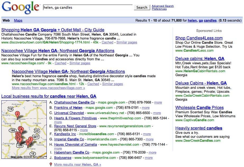
Google Universal search engine results page including Google Maps results.
By creating their own business listing, business owners are helping drive traffic to their site as well as customers through their front door. Millions use Google Maps each day and business listings are free through Google Local Business Center. Local Business Center is available to business owners with locations in Australia, Belgium, Canada, China, Japan, Finland, France, Germany, Ireland, Italy, the Netherlands, Norway, Singapore, South Africa, Spain, Taiwan, the UK, and the U. S.

Languages available in Google Local Business Center listings for Google Maps.
Before creating a new listing, it’s important to verify businesses aren’t already listed. One way of avoiding duplicate listings is to search for [your business name in your city, zip code] before submitting new listings. If a business is already listed, select “Claim your business” and if not continue to signup with Google Local Business Center.
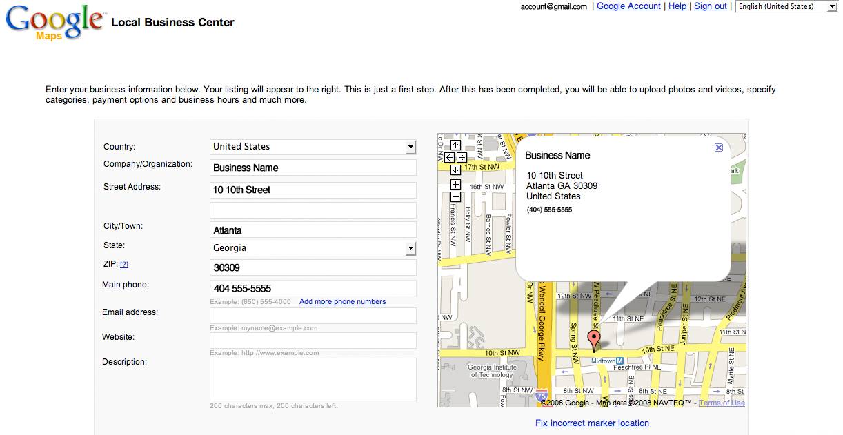
Example of information required.
In addition to general contact information, Google Local Business Center allows owners to specify hours of operation and accepted forms of payment. They can also provide up to 10 photos, 5 videos, offer coupons and more. The entire process is easy. Business owners have two options for receiving their personal identification number, either phone or mail. This PIN must be entered in the account before listings are activated. After the PIN is submitted, listings usually become active within a month.

Verification options in Google Local Business Center.
So no matter how large or small your business, inclusion in Google Maps can be a nice way of helping your business grow. In fact, even if you don’t have a “shop” it’s possible to create individual Google Maps listings like the listing I created in 2005 before phone verification was offered, using my own address at the time. At minimum, a name and phone number are required, though including more information may increase visibility in search results. Google suggests registering a physical address as well as including meta data along with categories, phone numbers, pictures, video and other details. They also suggest encouraging customers to leave honest comments and ratings in the Google Maps “Review” tab for business listings.
After all that, don’t forget to also include contact information in your site.
Mapping your map on the world
Have you ever wondered why some parts of the world don't have great maps and thought how nice it would be if they did? Building a map is an exceedingly complex process, and it is a challenge to reach all parts of the world. Today we unveiled Google Map Maker, a new product that allows users to contribute and edit Maps data for regions around the world.
Google Map Maker is a significant step in our ongoing efforts to engage Google Maps users and equip them with an easy-to-use tool to build high quality maps of their neighborhoods, cities and countries. Map Maker allows you and your peers to add, edit and moderate most features you see on maps including roads, lakes, parks, points of interest, businesses, cities and localities. You will be able to trace many of these features using satellite images; as you trace, maps are immediately updated.
As of today, you can build maps in the countries of Cyprus, Iceland, Pakistan, Vietnam and the Caribbean nations of: Antigua & Barbuda, Bahamas, Barbados, Bermuda, British Virgin Islands, Cayman Islands, Grenada, Jamaica, Netherlands Antilles, St. Kitts & Nevis, St. Lucia, St. Vincent & the Grenadines, Trinidad & Tobago. The existing mapping data for these countries could benefit tremendously from local knowledge and expertise that you and other map makers posses, and we're excited to see how you put that to use.
This product is a labor of love by many engineers based in Bangalore who have a desire to see the world mapped. Take a look at the before and after images from the Mapplet created to support relief efforts in Myanmar that we shared with you -- it was created with Map Maker!
Saturday, June 21, 2008
Embeddable Google Earth Maps
The new Google Earth plug-in for the browser has proved hugely popular. It has allowed Google Maps developers to include the added features of Google Earth within their mash-ups. If you are not a developer and you wish to add Google Earth to your own website or blog you now can as well thanks to the work of Street Cities and Google Earth Hacks.
Street Cities
Street Cities combines Google Street View and the Google Earth Browser to create a dual map that lets you view locations simultaneously on the ground and in the air. You can navigate around the Google Map in Street View and the Google Earth plug-in map follows your movements. There is something quite magical in watching the Google Earth plug-in map rotate as you turn around in Street View.
You can create your own dual map by selecting a location. Street Cities then produces the map and fa ew lines of code which you can use to embed the map in your own website or blog.
Google Earth Hacks
Google Earth Hacks have added the option to view their collections via the Google Earth browser plug-in. When you choose the Google Earth plug-in option the code to embed the map in your website or blog appears above the map.
Google Earth Hacks has a huge repository of geo-tagged collections. You are bound to find a collection that reflects your interests and now you can add this feature rich content to your own website simply by cutting and pasting a few lines of code.
Tuesday, June 17, 2008
Terrain Representation Updates in Google Maps
Mehmet K. noticed an update of the terrain layer from Google Maps, a feature that lets you view physical features, such as mountains and vegetation, with elevation shading.
The fairly recent "terrain" feature in Google Maps now plots contours as well as hill shading. The only problem that I can see is that the contours are in feet in the UK whereas feet are only really used in the States. Even in the UK where we still use miles for our roads, looking at familiar hill heights in feet is very off putting. When I looked at other countries (Kenya) the heights there were in meters.
"Contour lines are lines drawn on a map connecting points of equal elevation. If you walk along a contour line you neither gain or lose elevation." The other method used for representing terrain, "hill shading is a computer based mapping technique that shades each area of the surface to proportional to the amount of light that would be reflected off the surface from a light source at a specified location, usually to the northwest of the area of interest. Hill shading produces a planimetrically correct map that looks like a three-dimensional view of the surface."

Back in April, Google's geo blog mentioned some practical uses for these features. "Now, at a glance you can see the height of the world's peaks, or plan your next camping trip. Contour lines can even help you find a flatter bike route for your daily commute, which is key if you live in a city like Seattle."
Friday, June 13, 2008
Things You Can Do With Google Maps
Brian Ussery is director of SEO at Search Discovery in Atlanta, Georgia, and develops using Google’s tools and APIs.
The Google Maps team has been hard at work launching a number of new features in recent months. In case you’ve missed them, here are a few of the features available in Google Maps these days.
“Get directions” with Google Maps Street View
Google’s Street View was released a year ago and includes imagery for 37 major metropolitan areas in the US. In addition to the stand-alone version, Street View is now included in Google Maps directions. Street View directions make it possible for users to virtually tour new destinations before their arrival. Using Google Maps Street View in directions is simple: click on the “Get directions” tab and if Street View imagery is available it will be indicated by a camera icon and outlined in blue.
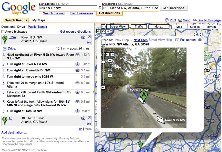
Google Maps StreetView “Get directions” feature
“Get directions" for Public Transportation in Google Maps
The Google Maps “Public Transit” feature allows users to map entire trips using public transportation and all within Google Maps. To use this feature, search for directions in Google Maps and if transit information is available it will be indicated by a “Public Transit” option in the directions tab. With this option users can get step-by-step transit directions in addition to transit stop locations, station information, schedules and more.
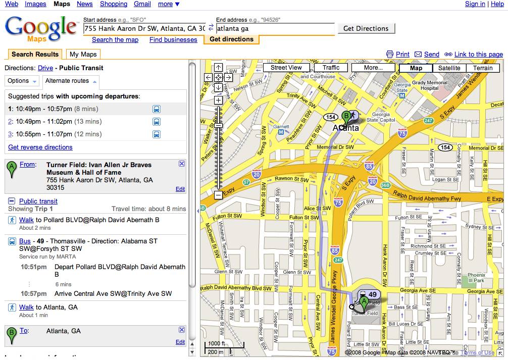
Google Maps Public Transit “Get directions” feature
Find Future Traffic Conditions with Google Maps
Most folks know about the “Traffic” feature in Google Maps but, now users can use Google Maps for information about future traffic conditions. To use the feature, click on “change” in the “Live Traffic” box near the upper right hand corner of your traffic map. Google Maps “Traffic” uses traffic data from 30 major US metropolitan areas to map traffic flow in real-time so drivers know what areas to avoid. Traffic conditions in Google Maps are denoted by color. Green means traffic is moving at an average speed of more than 50mph, yellow 25-50mph, red indicates traffic is moving at less than 25mph and gray indicates that data is not available.
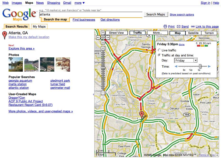
Google Maps Traffic prediction feature in action
More “Photos” in Google Maps
Depending on the user query, Google Maps includes a “Photo” option where users can view geographically relevant imagery based on location and provided by Google’s Panoramio image library. To access the Google Maps “Photos” feature, click “More” and select “Photos”. In addition to viewing images, users can add their own photos by uploading them to Panoramio.com.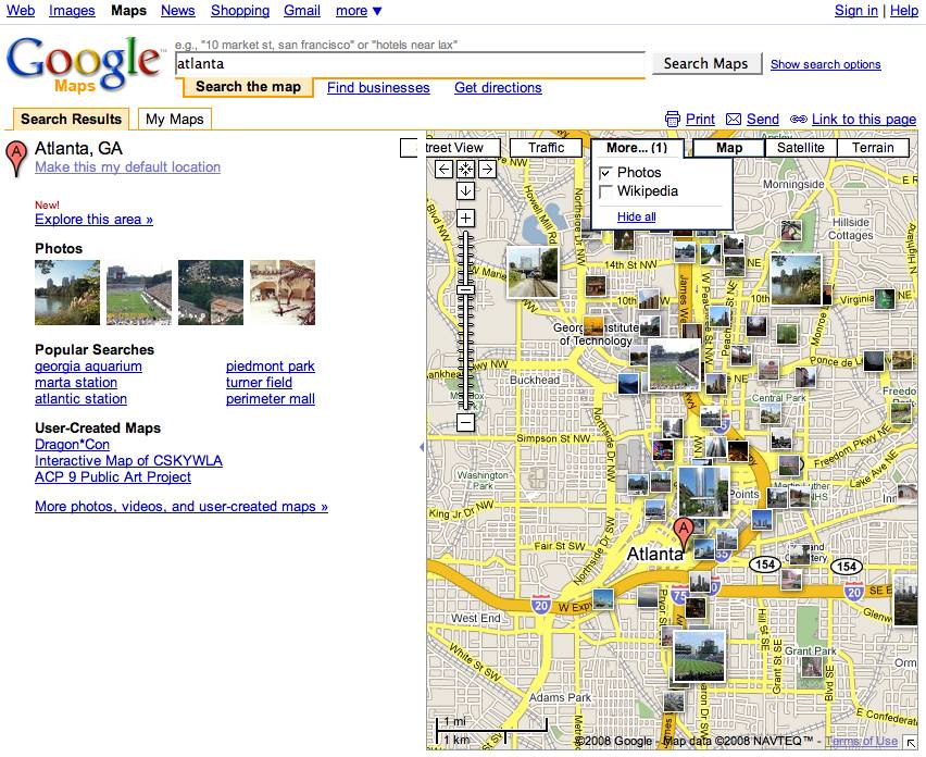
Google Maps Photo results in Google Maps
More “Wikipedia” Map Results
Thanks to Wikipedia’s Geographical coordinates Google Maps now includes Wikipedia articles in Maps results relevant to user queries and based on the geographical location of results. According to Wikipedia, “Any Wikipedian may participate in this project to better organize information in articles containing geographical coordinates.” The example below shows a search for “Atlanta” and includes a Wikipedia icon for the Georgia Aquarium at “Coordinates 33.76250, -84.39400” top right in the page.

Wikipedia results in Google Maps
Google Maps Video
Google Video and YouTube users have the option of providing geographic information when entering descriptions for their videos. Google Maps uses this information to map videos and make them available in Google Maps based on geographic location.
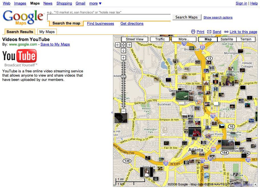
Video results in Google Maps
Google Maps Edits
When users find an error in a Google Maps locations or details, they can correct it using the “Edit” feature. By using the edit feature users can remove a place, add new places, flag inappropriate content and even view the edit history for locations in Google Maps. Google’s “Recent Edits” shows edits by other users in real-time.
In addition to all of the above, user can create their own maps in Google Maps: Customizing Google Maps is easy! Google Maps allows users to overlay weather, photos, public transit maps and original content. In addition, Google Maps allows users to interact with Google Maps tools and maps created by Google developers. Google Maps users can share, personalize, track and save maps all by setting up a Google Maps account. You might want to check out some of these features next time you pay a visit to Google’s mapping program.
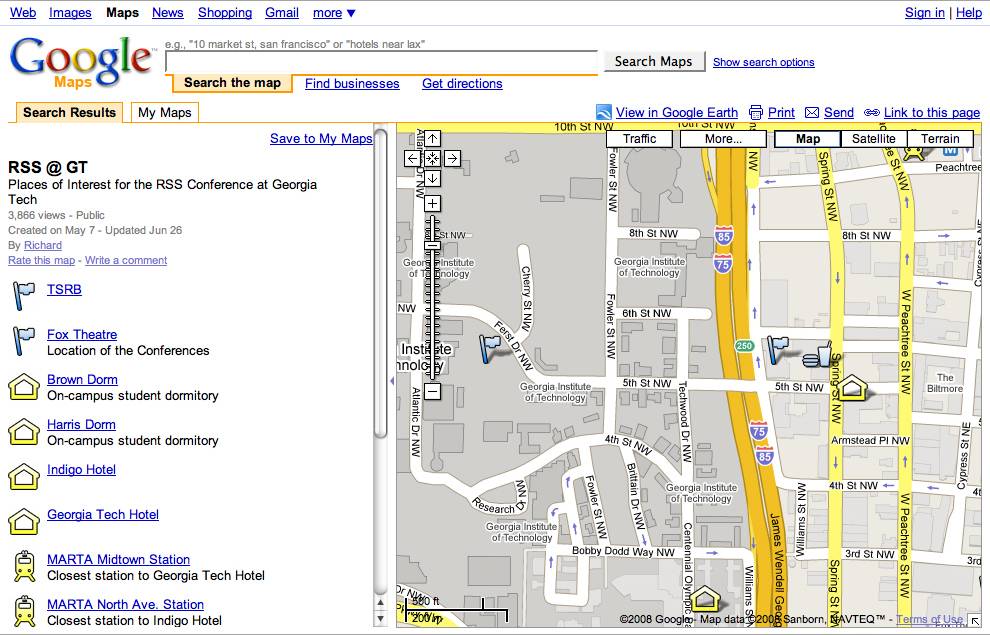
Example “My map" for Georgia Tech’s Conference on RSS
Thursday, June 12, 2008
Search Photos on Google Maps
Tickr
Sometimes the best ideas are also the simplest ones. Tickr is a simple idea but also a great one. In essence Tickr lets you search Flickr by keyword and location.
Why is that so great? Well, it means you can make some great visual comparisons of different cultures around the world. For example, the images in this post show some of the differences in fashion in California and Japan. I've just spent at least one happy hour comparing 'houses', 'pubs' and 'businessmen' in different countries.
The examples on the Tickr homepage include 'architecture' in 'Rome' and also 'glaciers' in 'Alaska'. The latter example is a good demonstration of another feature of Tickr - the time-line. As well as showing the location of photos on a Google Map, Tickr also presents the photos in a time-line based on when the photographs were taken. This means that in the given example it is possible to compare photographs of glaciers taken in 2001 to photographs taken this year.
Wednesday, June 11, 2008
Google Updates Street View Imagery in 37 New Areas of US
In celebration of Street View's first year of public availability, Google has made a major update to the Street View imagery. Unfortunately, none of the imagery is outside the US yet (despite the many sightings of Street View cars taking imagery in Europe). But, this update not only includes the many new cities in over a dozen states, but also updated and expanded coverage in many of the cities which already had Street View imagery. In particular, Google says more of the imagery now has more spherical panoramas (so you can look up and down in addition to 360 degree panoramas). And, they've worked on improving resolution and picture quality. Also, all the imagery has been processed with their new face-blurring technology to address some privacy concerns. Not only that, but the entire update is also available in the Google Earth Street View layer. Just to whet your appetite, here's one of the new cities:
View Larger Map
Read the full details on the new and expanded coverage over at Google's LatLong Blog. And, to see interesting sights found in Street View, or to share interesting things you find in the new imagery, try out Google Earth Hack's new Street View sightings database.
P.S. My apologies for the small number of posts the last few days. Had a bit of family crisis when my nephew Jason was involved in a traffic accident. Thankfully, he is miraculously all right now, and should completely mend in a few weeks. The other good news is that I got to do some flying in a Cessna between several states during the last few days.
Monday, June 09, 2008
Flight Simulator in Google Maps
Mini Flight Sim
The amazing James Stafford is the first to produce a flight sim for the new Google Earth Browser plug-in.
The plane permanently hugs the earth, and the gas pedal is permanently down. This means you have no control over the altitude or speed - but you do have to steer left and right using the cursor keys as the world zooms by beneath your feet.
This Mini Flight Sim also comes with a teleport option so you can jump to any location in the world.
I would tell you more but I have to get back to playing with this amazing game.
Check out James' blog barnabu if you are interested in finding out more about how he produced this incredible flight simulator.
Saturday, June 07, 2008
TME - Thematic Mapping Engine, Plugin - Google Earth
 Periodically during the last three years since Google Earth was released, some talented developer gets the Google Earth bug and develops a wave of cool stuff. Right now, the guy with the most momentum is Bjørn Sandvik at the United Nations Association (UNA) of Norway. He's written a flood of blog posts in the last few weeks at his Thematic Mapping Blog with really innovative visualizations and applications of GIS technology for Google Earth. This week, he's released a cool new application he calls the Thematic Mapping Engine (TME). TME lets you easily take data (no programming required!) from UNdata and create initially 3D prism charts (country shape files represent data about each according to height for things like life expectancy, population, etc.). Bjørn's TME lets you easily create different charts and view them in Google Earth in 3D. He also has plans for other kinds of chart projections/symbols. Not only that, but based on initial feedback, he's now added the ability to view the output using the new Earth API plugin. So, if you're on Windows with a supported browser, you can view the output right on the web page. The screenshot here shows one of the charts with the plugin. You can still get a KML version for loading in the full GE as well. Great idea!
Friday, June 06, 2008
Drive on Google Maps with Katsuomi Kobayashi - from Japan
Hi! I'm Katsuomi Kobayashi, a developer from Osaka, Japan. I'm delighted to write as a guest on this blog.
2D Driving Simulator on Google Maps is a personal project of mine. With the power of Google Maps, you can drive around the world without having to worry about spending money on expensive gas. And it is using the brand-new Flash API which Google released two weeks ago.

My original 2D Driving Simulator is a Flash toy that simulates car parking and trailer movement. In my second release of the toy, I added in wide courses to make it a bit more fun (and less crash-prone). When I tried to add in more natural courses and realized how difficult it was, I decided to test out using the real roads of Google Maps as a backdrop.
At the time of that decision, the Google Maps API was only available in Javascript - so I actually had to find a way to overlay the Flash toy on top of a Javascript map and synchronize them. Amazingly, it actually somewhat worked. Unfortunately, it's 'success' relied on the troublesome wmode=transparent Flash parameter, and on having to call JavaScript from Flash 20 times a second (certainly not a typical thing to do).
So, the release of the Google Maps API for Flash was truly happy news for me. I implemented it right away. It was easy to replace the JS API; it only took a few hours. All I had to do was to add a com.google.maps.Map child on the main Sprite, copy the JavaScript functions to ActionScript, and adapt them according to the API's minor differences.
The result is very impressive: there is both an increased frame rate (from 15-20 fps to 40 fps) *and* a decreased CPU usage. Moreover, the map perfectly follows the vehicle's movement. Quite natural!
The Google Maps API for Flash has enabled us developers to create real-time Google Maps applications. I believe this excellent API has unlimited potential and look forward to using more of it in the future.
Subscribe to:
Posts (Atom)

 Posts
Posts


