Asfaar Burhaniyah 2.0

Asfaar Mubaraka of al Dai al Fatemi Syedna Mohammad Burhanuddin (tus) across the globe since 1424. (previous asfaar shall be added too insha allah as soon as possible.)The Placemark centered is the Current Location of His Holiness Dr. Syedna Mohammad Burhanuddin (TUS). comments are welcome.
Showing posts with label earth. Show all posts

Tuesday, July 15, 2008

Google Earth Imagery Update Quiz

Today I'm happy to announce that we've just finished pushing out an imagery update for all you Google Earth fans out there. As usual, I'll drop a few hints at where these updates might be, and tomorrow I'll post the complete list of updates.


1) Founded in 1608, this former British possession has a decidedly French flair.


2) Once the seat of great political power, this red fortress is now a major tourist attraction.


3) Now a UNESCO World Heritage Site, this city was lost to the world for 1700 years.


4) Passing by a famous golf course and luxurious mansions, this stretch of road is a tourist attraction in its own right.


5) Legend has it that Hercules founded this major European city.


6) This city within a city plays host to an Opera House, Planetarium, Science Museum, Oceanographic Park, and beautiful gardens.
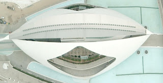


7) When we updated imagery of this city, we got complete coverage of another country with it.


8) This city hosted General MacArthur's South West Pacific Headquarters during WWII.


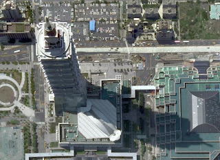
9) Some of my Googler co-workers can enjoy the views from this very tall building.


Monday, July 14, 2008

Ground Art in Google Earth

Dutch artist Henk Hofstra has done a couple of interesting large outdoor "urban art" projects. The first is a "Blue Road". He painted 1000 meters of road in bright blue in Drachten, The Netherlands - on top was the phrase "Water is Life" written in eight-metre-high letters. The road was painted (using 4000 liters of paint) in April of 2007, and Hofstra hoped it would show up in Google Earth - but, the imagery for Drachten in GE is still dated 2005 currently (no new aerial or satellite photo has been acquired by Google for the area). I did notice the artist had some aerial photos taken of the road. I've placed one of the photos in a Photo Overlay for Google Earth - load this file and double click on the placemark to be flown into the Photo Overlay where you can see how closely the photo of the Blue Road matches the road in Google Earth. Try the transparency slider to check the underlying imagery.
Art Eggcident by Henk Hofstra in Google EarthMore recently, in May of 2008, Henk Hofstra has done another outdoor art project called "Art-Eggcident". In this case he has created 100 foot wide fried eggs in a large square in Leeuwarden, The Netherlands. Some of the eggs even have 3D yolks kids can crawl on (see more photos). Amazingly, the city is allowing the art project to stay in place for the next 6 months. We can hope a proper orthographic aerial photo (straight down), or a satellite photo will capture this cool looking art project so it can be seen in the Google Earth images. But, in the meantime, I have again taken one of the aerial photos and made a Photo Overlay so you can see a photo of the Art Eggcident in its actual location in Google Earth.
This is just a reminder that if you do some large outdoor project you want to be visible in Google Earth. You can always take your own aerial photo and place it with the Photo Overlay or Image Overlay tools in Google Earth. That way it is still "immortalized".

GEB announces July 2008 Imagery Update for Google Earth

I've started getting reports of new imagery available in Google Earth today! The update is occurring as I write this because not everyone is seeing the new images yet, but it will probably be fully deployed within a few hours. Here are a few places I've confirmed (I will update this list as people tell me about other places - leave comments below please):
[UPDATED 1130, 1143, 1150, 1410, 2220 EDT]

  • Catalonia/Spain - My story about 3D Roses is a popular story right now, and that's where people first started reporting the new imagery. The entire Catalonia area has new imagery mostly dated September 2006 by the Institut Cartográfic de Catalunya. Also, Murcia, Zaragoza, Toledo, Granada, Cuenca and Cáceres (see comment below). Also, Valencia. Also: Lleida, Tarragona, Barcelona
  • Portugal - Looks like areas in Portugal have new imagery.
  • Czech Republic - entire country has Spot Image (medium resolution 2.5 meter)
  • Slovakia - entire country with Spot Image
  • Hungary - entire country with Spot Image
  • Croatia - Notheastern part
  • Australia - All of western Australia has Spot Image as well! Also, some new low resolution imagery for the Great Barrier Reef area off North Eastern Australia (see dark colored imagery). Adelaide, Brisbane, Tasmania
  • USA - Looks like all of New Mexico has high resolution now. Credits to NMR GIS dated July 2005.
  • Mexico - Central Mexico has Spot Image imagery
  • Italy - Rome, Naples
  • Venezuela - Maracaibo (Thanks Gerardo!)
  • Germany - center of Munich
  • Canada - Quebec, Southern Ottawa
  • California - Areas around San Francisco, San Diego, Benicia, Solano County, Monterey, Palo Alto, Los Angeles (unconfirmed)
  • England - Bristol, Worcester, Evesham
  • Cote d'lvoire - BouakĂ©
You can confirm whether the imagery is new by clicking on the "View in Google Maps" icon in GE - the imagery in Google Maps isn't showing the new data yet. If you find new areas not in my list above, please leave a comment and I'll update the list.

Saturday, July 12, 2008

Google Earth 4.3 (beta) Update Available - Version 4.3.7284.3916

There's a new version of Google Earth 4.3 (beta) available. This release does not appear to introduce new features, but it does address a number of issues some of you have encountered with GE 4.3 which was released in April. Since Google has had a couple of months, I'm expecting this version to be a more stable version to use. I'm still waiting for an official report and release notes, and will add the details here when they are available. See the official release notes for this update below. There's a lot of fixes to a variety of problems - many that only applied to certain OSes, or system configurations. Head on over to the official Google Earth Download page to get the latest (the "Check for Update" currently won't find this new release.)
See the initial review of Google Earth 4.3 for reasons why you should get the new version if you are still running an older version of Google Earth. Or, check out the GEB video demo of GE 4.3:

Popout


Friday, July 11, 2008

First 3D City in Spain for Google Earth - Roses

Roses Spain in 3D in Google EarthRoses is the first city in Spain to get their entire city in 3D for Google Earth. The models are currently the basic gray buildings without textures. But, they are part of the Google Earth 3D Buildings layer. Just search for "Roses, Spain" to see for yourself. Google has a program called Cities in 3D (read more) to help city planners provide Google with data so their cities can be included in the layer. The program was just expanded to several European countries (including Spain) in early June. According to GEB reader Albert Garcia, they are also working to add SketchUp models with photo-textures for Roses.
Google has dozens of cities now where a large percentage of the urban area is modeled in 3D (more in the US than any other country at the moment). Here is a list of some cities in Europe where most of the city is in 3D: Zurich, Munich, Amsterdam, Hamburg, and Westport in Ireland. Berlin also has a huge 3D collection they created themselves, but it's not part of the built-in GE layer. Similarly, Dresden in Germany also did their own layer which is not yet part of the built-in layer. And, let's not forget, probably the most 3D data available for any country is in Japan. Nearly every structure for several major cities is rendered if you turn on the 3D Buildings layer and visit cities in Japan.

Thursday, July 10, 2008

Model Your Campus - Results are Out


We are happy to announce the winners for the Google 2008 International Model Your Campus Competition! Congratulations to the talented students who took on such a challenging project. You can see their amazing models in Google Earth by turning on the 3D Buildings layer and navigating over to each campus, or you can see their individual collections in our 3D Warehouse. The winning schools are:


  • Johns Hopkins University (Student Technology Services & Digital Media Center; United States)

  • Zhongnan University of Economics and Law (China)

  • University of Wisconsin-Madison (Department of Engineering; United States)

  • Missouri University of Science and Technology (Department of Physical Facilities; United States)

  • Nicolas Copernicus University (Department of Biology and Earth Sciences; Poland)

  • Stockholm University and KTH (Department of Computer and Systems Sciences; Sweden)

  • Cardiff University (Department of Information Services; United Kingdom)

  • Bournemouth University (The Business School; United Kingdom)

  • Peking University (School of Electronics Engineering and Computer Science; China)


WebCams Layer for Google Earth

Webcams.travel webcams in Google EarthBack on the 1st of June, I mentioned and shared a new KMLd collection by Webcams.travel showing 4500 web cams around the world as placemarks in Google Earth. This morning, I noticed the layer has been incorporated into Google Earth. You'll see it in the Geographic Web->Preview layer. Or, you can look for it under Gallery->Webcams.travel. Open up the oval-shaped placemarks to see the current webcam view for that location. See the example in the screenshot of the beach at Fort Lauderdale, Florida. The Webcams.travel collection is certainly the largest collection of webcams I've seen in Google Earth. However, be aware that the placemarks are user-generated. Many of the webcam placements are inaccurate (e.g. I found two placemarks of Guadaloupe that are actually webcams for St. Barts, and several other wrong labels or placements in other Caribbean islands).
There have been many other smaller placemark collections showing webcams. Here are a few written about here at GEB:

Tuesday, July 08, 2008

Measure it in Live Maps

This post by Greg Sterling this AM is a good reminder to tell you about one of my favorite features on Live Maps – Distance and Area calculations. If you ever wanted to know how far it is between 2 cities or what the area of the surface of a given lake is, Live Maps drawing tools make it really easy.
Even without drawing you can calculate directions to get the approximate drive time and distance between any 2 points by right clicking and choosing ‘Drive From…’ and ‘Drive to…’. Live maps has intercity vector map data for just about everywhere on Earth, including places it doesn’t have detailed city streets for.
image
But you can tailor the trail by using the Collections –> Open Your Collections  menu to draw your own lines or shapes. Whether it is a simple 2 point line or a complex closed polygon, Live Maps will show you the distance and area/perimeter respectively. Here is Greg’s ‘Crow Flies’ distance from Haifa to Sfat
image
And here is a Polygon drawn around the nearby Sea of Galilee showing that it is 63.33 Square Miles. If you sign in with your Live ID you can save your drawings in the cloud making them easy to share with others without the need for really long URL’s.

image

Thursday, July 03, 2008

Surat - Skyline Panorama in Google Earth

I am so Happy to hear that Yesterday Panoramio added photos up to ID 10760000 to Google Earth, that means around 750,000 new photos improving the experience in Google Earth. That also means that out of my 2 previously mentioned Panoramas, First one (id: 10410584) is now viewable in Google Earth. The next update will be around August 10th and will include photos reviewed before July 27th which may include my second one too.

Tuesday, July 01, 2008

Holographic Google Earth

Check out this cool display and interface with Google Earth:
Popout
Holographic Google Earth from Nicolas Loeillot on Vimeo.
The technology comes from UbiqWindow and lets a computer screen be projected in mid-air. They have devised a touchless way to interact with the "hologram", and Google Earth is a great way to show off its capabilities. it's not a 3D projection, just 2D. But, it sure looks cool

Saturday, June 28, 2008

KML Validator

Many of you are probably familiar with Feed Validator, a free service that checks to see if your feeds, including KML, are valid, and also makes recommendations based on best practices. Now Galdos Systems has released a new service, KML Validator, specifically for KML.


KML Validator gives you a nice simple interface, and helpfully displays relevant portions of the OGC KML spec to explain error messages. They provide two different ways to access their service: upload files for validation, or point to a URL of a file on the web. The site also has a helpful set of FAQs about KML.


For those of you who want to check your KML files, and want more than just basic XML Schema validation using the KML Schema, KML Validator offers a nice new choice.

Wednesday, June 25, 2008

EarthSwoop - Share and View 3D Places

EarthSwoop Using Google Earth PluginGoogle Earth Hacks and Google Earth Blog have gotten together to create a web site to allow people to share and view 3D locations using the Google Earth plugin. We're calling the site EarthSwoop for obvious reasons. Try the tour of NFL Stadiums, or MLB Stadiums and click on the team icons to "swoop" in to each 3D model of a stadium. There are already over a dozen collections to try out. Since the plugin is limited to Windows right now, you won't be able to see the 3D sites with Mac or Linux - but, Google has promised to have a new version in August supporting more browsers/OSes.

Sign up in the EarthSwoop forums and you can easily save and create your own collections with anyone. All you have to do is position the view with the plugin you want to share and click a button to save that location. Mickey did most of the work using tools he's been developing for his site. We wanted to see if you could create ways for people to not only view places, but also create their own tours. Let us know what you think either here or in the forums at the EarthSwoop site.

Monday, June 23, 2008

Embed Google Earth content on your site

Now that the Google Earth plugin works in Firefox 3 (Windows-only still…), we thought we’d run through some of the best ways to embed Google Earth content on your site.

5. Embed existing files and collections from Google Earth Hacks

Google Earth Hacks has over 20,000 files on their site, all of which can be embedded into your own. In addition, their collections can be embedded. Both implementations are very straightforward, but require that a file is already on their site. Here is what an embedded collection looks like:


Powered by Google Earth Hacks | More info about this collection

4. Embed golf courses from Golf Nation

Similar to Google Earth Hacks, Golf Nation allows you to embed any of their existing courses onto your own site. This could be pretty useful if you just played a round and want to embed that course into your blog post about your great score. The quality of the files can vary quite a bit, so here is one of the better ones:


Powered by Golf Nation | More golf courses in Atlanta

3. Build your own map with StreetCities

StreetCities is by far the most complex integration we’ve seen, for better and for worse. You have a ton of options on how you want your map to look, and it’s very well done. It’s not a great place to go for a quick map, but it’s worth playing with when you have a chance.

2. Easily embed a KML with TakItWithMe

TakItWithMe was the first site to offer the plugin in an embeddable manner. Their script is quite simple, and allows you pull a KML into the map. However, the KML needs to be hosted online somewhere (no upload feature), which is kind of a bummer. Still, it’s nice way to build a quick embed from any KML that you know of.

1. Embed a map in a few seconds with ShareIt

ShareIt is another entry from Google Earth Hacks, but this one takes the cake. There are no frills with this one — just a very simple way to embed the map on your site. Title it, find your location on the globe (either by zooming or by searching with the box below it), and that’s it. If you want a simple way to show your house, your church, your favorite stadium, etc, this is the way to do it.

Firefox 3 Now Runs Google Earth Plugin

As promised by Google in a comment on my post about Firefox 3 last Tuesday, Google has quietly fixed it so the Google Earth plugin (which lets you run a subset of Google Earth in your browser on a web page) now works with Firefox 3 (as of today - Sunday, June 22). Digital Earth Blog gets points for being the first GE blog to post about it. Google's Paul Rademacher (the chief architect behind the Google Earth API and plugin) posted an announcement about the support for Firefox 3 and that it does NOT require you to download a new plugin binary. Wanna check it out? Try the Milktruck game!

Saturday, June 21, 2008

Embeddable Google Earth Maps

The new Google Earth plug-in for the browser has proved hugely popular. It has allowed Google Maps developers to include the added features of Google Earth within their mash-ups. If you are not a developer and you wish to add Google Earth to your own website or blog you now can as well thanks to the work of Street Cities and Google Earth Hacks.

Street Cities


Street Cities combines Google Street View and the Google Earth Browser to create a dual map that lets you view locations simultaneously on the ground and in the air. You can navigate around the Google Map in Street View and the Google Earth plug-in map follows your movements. There is something quite magical in watching the Google Earth plug-in map rotate as you turn around in Street View.

You can create your own dual map by selecting a location. Street Cities then produces the map and fa ew lines of code which you can use to embed the map in your own website or blog.

Google Earth Hacks


Google Earth Hacks have added the option to view their collections via the Google Earth browser plug-in. When you choose the Google Earth plug-in option the code to embed the map in your website or blog appears above the map.

Google Earth Hacks has a huge repository of geo-tagged collections. You are bound to find a collection that reflects your interests and now you can add this feature rich content to your own website simply by cutting and pasting a few lines of code.

Virtual Reality Via Your Phone

Enkin is a new hand-held navigation concept being developed by two German 'computational visualists'. It combines GPS, orientation sensors, and what looks like Google Maps and Google Earth.

In essence Enkin seems to take placemarks that you have created in Google Maps and overlays them on top of a live video feed of the same location.

It looks absolutely amazing. Just watch the video to see what I mean.

Popout
Enkin from Enkin on Vimeo

I want the first pair of sunglasses these guys produce with a built in monitor. Augmented reality here we come.

You can learn more about the technical details of this at Enkin.net.

Scientific Applications of Google Earth

Tuesday, June 17, 2008

Google Earth plug-in to be Updated This week

Firefox 3 is set to be released tomorrow, and Mozilla is hoping for five million downloads. My concerns had been two-fold: Firefox 3 breaks the Google Toolbar and the Google Earth Plug-in. However, the toolbar has been updated today to work with FF3, but what about the plug-in?

There has been no word from Google about a possible update, so maybe it’s not coming. However, with Firefox 3 getting rave reviews, I would expect that the adoption rate will be quite high. I would hate to see the plug-in take a bit step back by suddenly not working on millions of computers…

Google Earth plug-in to be Updated This week

Firefox 3 is set to be released tomorrow, and Mozilla is hoping for five million downloads. My concerns had been two-fold: Firefox 3 breaks the Google Toolbar and the Google Earth Plug-in. However, the toolbar has been updated today to work with FF3, but what about the plug-in?

There has been no word from Google about a possible update, so maybe it’s not coming. However, with Firefox 3 getting rave reviews, I would expect that the adoption rate will be quite high. I would hate to see the plug-in take a bit step back by suddenly not working on millions of computers…

Google Apps + Bollywood Movie Stars ??

This week our Google Innovation seminar series was in Minneapolis, MN and Atlanta, GA demonstrating how Google Enterprise technology can help larger organizations innovate faster. When I demo Google Apps, I usually try to develop some plausable, but interesting scenario - creating an intranet site with Google Sites to coordinate an upcoming product launch, collaborating on sales projections with an external vendor using Google Docs, etc. However, real Google Apps customer stories are invariably more interesting and unexpected. Check out this video where David Shapiro of Congregational Security Inc. talks about his company's use of Apps, Google Earth and other Google technologies to protect VIPs, from Bollywood stars to religious dignataries.
Popout
via Official Google Enterprise Blog

Where Am I